
Quick Links
- Contingent Plan of the district
- Programmes and Schemes
- List of service provider
- Spots for exposure visit
- Newsletter and Publications
- SAC Meeting and Proceeding
- Important Events
- Success Stories
- List of Awardee farmer/staff
- GIS Maps of KVK Activities
- Key Technologies
- Sponsored Programmes/Project
- Facilities
- Fertility map of the instructional farm
- Instructional farm plan and layout
- Crop Planning
- Production of instruction farm
- Products/inputs
- Citizen Client Charter
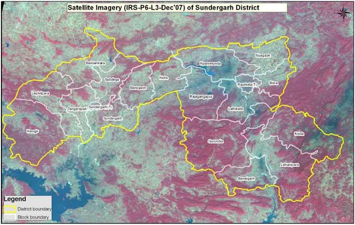
District Profile
The district lies in the north western portion of the State. It is bounded
on the north by Jharkhand State, on the south by Jharsuguda, Sambalpur
and Deogarh districts, on east and north-east by Keonjhar and Paschimi
Singhbhum districts of Odisha and Jharkhand, on the west and north-west
Raigarh district of Chhatisgarh. The district headquarters is located at
Sundargarh.
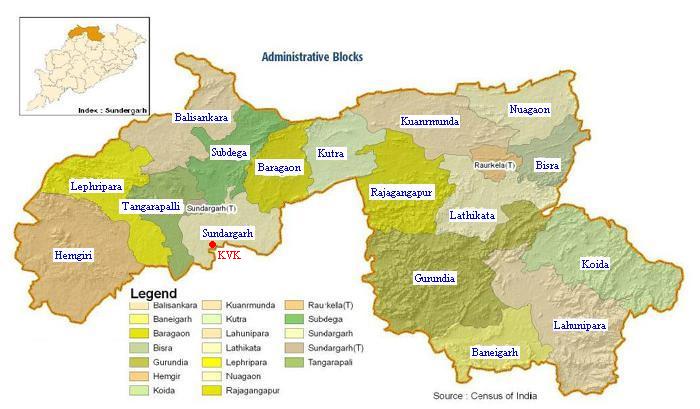
| Head quarter | Sundargarh | Population | 18,30,673 | |
| Sub division | 3 | Male | 9,35,473 | |
| Blocks | 17 | Female | 8,95,200 | |
| Tahasils | 12 | SC | 15,7804 (8.62%) | |
| Municipality | 4 | ST | 9,19,180 (50.21%) | |
| Grama panchayat | 262 | General | 7,53,689 (41.17%) | |
| Villages | 1,744 | Total population of the farmers of the district | 1,45,639 | |
| Assembly seats | 7 | Male in Agril. | 2,37,379 | |
| Towns | 9 | Female in Agril. | 2,02,028 | |
| Literacy Rate | 65.22 % | Male in Non-Agril. | 1,88,162 | |
| Longitude | 83032'-85022'E | Female in Non-Agril. | 1,12,544 | |
| Latitude | 20035'-22032'N | Work force in Agril. | 43,94,070 | |
| MSL | 300 m | Work force in Non-Agril. | 3,00,706 | |
| Temperature (Max) | 260 - 410 C | Geographical Area | 9,712 Sq. Kms. | |
| Temperature (Min) | 120 - 280 C | Area | 9,71,244 ha. | |
| Avg. Rainfall | 1200 mm | Total cultivable land in the district (ha.) | 3,36,050 | |
| Avg. Rainy days | 60 | Misc. tree crops & grooves | 3,897 ha. (16.53%) | |
| Relative Humidity | 47 - 89% | Permanent pasture & other grazing area | 30,349 ha. (3.12%) | |
| Wind Velocity | 2 - 7 km/hour | Cultivable waste | 39,945 ha. (4.11%) | |
| Small Farmers | 50,338 | Land put to non-agril. uses | 49,249 ha. | |
| Marginal Farmers | 62,817 | Barren & uncultivable land | 41,562 ha. | |
| Big Farmers | 32,484 | Current Fallow | 61,109 ha. | |
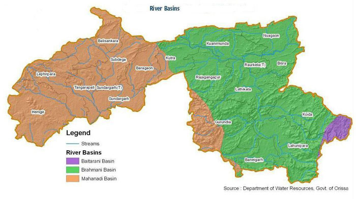
| Major rivers | Brahmani Sankh & Koel – Tributary of Brahmani IB- Tributary of Mahanadi | Other fallow | 41,325 ha. | |
| Forest area | 1,60,583 ha. | |||
| Major crops of the district | Paddy, black gram, green gram, arhar, horse gram, sesamum, groundnut, mustard, wheat and maize | Net Area sown | 3,13,000 ha. (32.22%) | |
| Irrigated land (ha.) | 31,924 | |||
| Rain-fed land (ha.) | 3,04,126 |
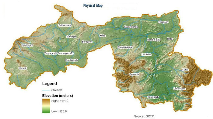
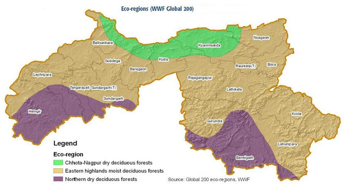
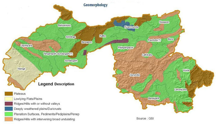
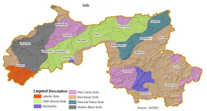
Geographically, the district is not a compact unit and consists of widely, dissimilar tracts of expansive and fairly open country, dotted with isolated peaks, inaccessible forests, river valley and mountainous terrain. Broadly speaking it is an undulating table-land of different elevations broken up by rugged hill ranges and cut off by torrential hill streams and the river lb and Brahmani. The general slope of the district is from north to south. There is a open well-cultivated plain country along the valley of the lb river particularly in the south. The rest of the Sadar sub-division consists of undulating table-land about 700 ft. in average height, dotted here and there with hills and peaks rising to about 2000ft., in the western most tracts at hemgir P.S. in the north there is a gradual rise to the table-land of Chhotanagpur. The portion occupied by Bonai sub-division to the south-east has rugged forest and hills intersected by gorges and passes and having a narrow valley of the Brahmani river and its tributaries. For a short spell of time during the rainy season the rapid current of the hill-streams cut off communication. The east and west of the brahmani valley is filled with high range of mountains, ft.) Chheliatoka (3331 ft.) and Bichakani (2964 ft.) in the east. The last hill has acquired importance as it contains million of tonnes of iron-ore for use in Rourkela steel plant. The territory of Sundargah and Panposh sub-divisions comprising the ex-states of Ganagpur is about 700 ft. above the sea level. Bonai sub-division comprising ex-State of Bonai is about 800 ft. above the sea level. The forest of the district is of northern tropical dry deciduous type, mainly containing Sal, Assan and Kurum. The eastern half of Bonai and Rajagangapur contain better quality of vegetation. The forest area is mostly studded with rich mineral deposits, like iron ore, manganese, limestone, lead; also forest products like bamboo, timber and kendu leaf which are export-oriented. The district was a very inaccessible tract having no proper communication. The tribal people living in the area used to subsist for the most part of shifting cultivation which resulted in denudation of forest The forest occupy an area of 3534.92 sq.kms which includes 2664.64 sq. kms. under reserved forest and 612.07 sq.kms. under protected forest. The forests are of northern tropical dry deciduous type. Sal is the dominant species. The eastern half of Bonai contain better quality of vegetation. The principal forest produce are timber, kendu-leaf and bamboo besides minor product like sabai grass. lac, tassar, myrabolan, mahua, kusuma seed, resin, tamarind, gum and sal seed.